Battle of London
(Marker Number: 560)
Location: London, Courthouse lawn, Main St., US 25

Leonidas C. Houk
Description: 500 CSA cavalry led by Colonel J. S. Scott attacked 200 USA troops and 98 convalescents under Colonel L. C. Houk here Aug. 17, 1862; killed 13, wounded 17, captured 111 men and 40 wagons. CSA lost 2 killed, 4

Col. John S. Scott
wounded. Houk forced back to Gen. George W. Morgan’s main USA force at Cumberland Gap. Cut off from supplies, Morgan began his retreat to Ohio thirty days later.
Camp Ground Methodist Church
(Marker Number: 1574)
Location: Approx. 7 mi. S. of London, KY 229

Bishop Francis Asbury
Description: Known as camping ground as early as 1811, this was a favorite spot for both Indians and whites. Bishop Francis Asbury, en route to first Methodist conference in Kentucky, 1790, held worship near here. First church was of logs, erected by a generous gift from Amos Shinkle, who was president of The Covington-Cincinnati Bridge Company. Present building was constructed in 1876.
Camp Wildcat
(Marker Number: 1919)
Location: Hazel Patch, 7 mi. NW of London, US 25

Felix K. Zollicoffer
Description: Led by Gen. Felix K. Zollicoffer, 7,500 Confederates on October 21, 1861, attacked the entrenched camp of 5,000 Union men under Gen. Albin Schoepf. Union’s natural defense advantage in the Rockcastle Hills stopped the Southern troops, who retreated to Tenn. This was major battle during 4 days of skirmishes, attacks, and heavy gunfire. Over. Presented by Laurel County Bicentennial Commission and Forest Service, USDA.

Albin F. Schoepf
(Reverse) Union Civil War Camp – The Camp Wildcat position was considered crucial for each side. Union forces camped two miles north of here to prevent Confederate attack into the Bluegrass region of Kentucky. Confederates wanted to prevent Union advance into eastern Tennessee, where many citizens remained loyal to the Union. Presented by Laurel County Bicentennial Commission and Forest Service, USDA.
Congressmen Buried in London
(Marker Number: 2113)

William H. Randall
Location: London, A. R. Dyche Memorial Park, 1225 S. Main St., US 25, near KY 229
Description: Wm. H. Randall (1822-81), lawyer, co. clerk, judge, 8th dist. rep. in 38th and 39th Congresses, buried in family plot on East 1st Street.

Vincent Boreing
Vincent Boreing (1839-1903), newspaperman, 1st lt. Union army, school supt., 11th dist. rep. in 56th and 57th Congresses, buried in the A. R. Dyche Memorial Park. Over. Presented by Laurel County Fiscal Court.
(Reverse) Congressmen Buried in A. R. Dyche

Don Calvin Edwards
Memorial Park – D. C. Edwards (1861-1938), lumber business, pres. The National Bank, London, 11th dist. rep., 59th-61st Congresses.

Finley Hamilton
Finley Hamilton (1885-1940), lawyer, WW I Signal Corps, elected at large to 73rd Congress.

William Lewis
Wm. Lewis (1868-1959), commonwealth’s atty., state rep., filled John Robsion’s unexpired term, 80th Congress, seated 1948.
CSA Returns to Tenn.
(Marker Number: 737)

Braxton Bragg
Location: 4-H Camp entrance, 4 mi. S. of London, KY 229
Description: After Battle of Perryville, Oct. 8, 1862, CSA gathered at Bryantsville on 11th. Pursuing Union force did not attack, but destroyed sources of food. CSA Gen. Bragg started moving forces south, Oct. 13. USA under Gen. Buell pursued to here, where he decided further pursuit was not expedient. CSA continued on, passing thru Cumberland Gap, Oct. 19-24. See map on other side.
Defeated Camp Burial Ground
(Marker Number: 102)
Location: 2 mi. S. of London, Levi Jackson State Park, near McHargue’s Mill, US 25

Defeated Camp Burial Site
Description: The McNitt Company, a group of early settlers organized in Virginia for protection on the trip to Kentucky settlements, was camped here on Boone’s Trace. Failing to post a guard they were massacred by Indians on October 3, 1786. The victims were buried here at the site of their last camp.
First Lt. Carl H. Dodd (1925-1996)
(Marker Number: 2033)
Location: Lily, Cumberland Memorial Gardens
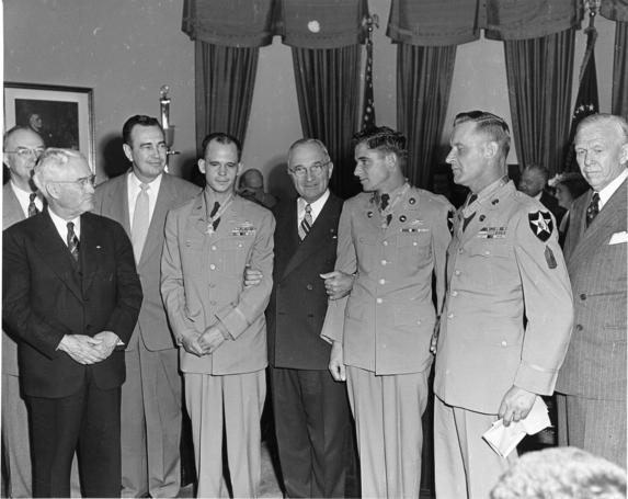
President Harry S. Truman with Korean War veterans on May 19, 1951 after awarding each the
Congressional Medal of Honor. From left to right: three unidentified men, First Lieutenant Carl Dodd,
President Truman, Sergeant John A. Pittman, Master Sergeant Ernest R. Kouma, and Secretary of Defense George C. Marshall.
Description: This Medal of Honor recipient was born in Harlan Co. Dodd served with Co. E, 5th Regimental Combat Team, U.S. Army. He was awarded the medal for heroic action in the Korean War for capture of Hill 256, a key terrain, with utter disregard for his safety, January 1951, near Subuk, Korea.
(Reverse) Medal of Honor Winner – President Harry S. Truman presented Carl H. Dodd with this award in May 1951. He achieved the rank of major before retiring from the U.S. Army on June 30, 1965. He lived in Laurel County the last 33 years of his life. Died on October 13, 1996. Presented by VFW Post 3167, Williamsburg; VFW Post 3302, London; VFW District 11; DAV Chapter 158, Keavy; John C. Karr; and Walter Setzer.
Laurel County
(Marker Number: 1176)
Location: Levi Jackson State Park, at Mountain Life Museum

Laurel County 1895
Description: Formed in 1825 out of portions of Clay, Rockcastle, Whitley, and Knox counties. The abundance and beauty of laurel shrub impressed the early pioneers so much that they named the county for it. Dr. Thomas Walker’s party, exploring for the Loyal Land Company of England, first came to the area in 1750, naming the streams after different members of his party.
Laurel Seminary
(Marker Number: 661)
Location: London Elem. School, N. Main St., US 25

Laurel Seminary
Description: In 1826, the legislature granted land to Laurel and some other counties for educational purposes. Land sold; Seminary opened, 1858. Used for hospital in Civil War. Gov. W. S. Taylor called special session of legislature here, 1900. Common school, 1870-84; private school, 1884-93; common school, 1893-1906; then public school. Original building replaced, 1954.
Modrel’s Station
(Marker Number: 1870)
Location: Near crossing of Laurel River, KY 229
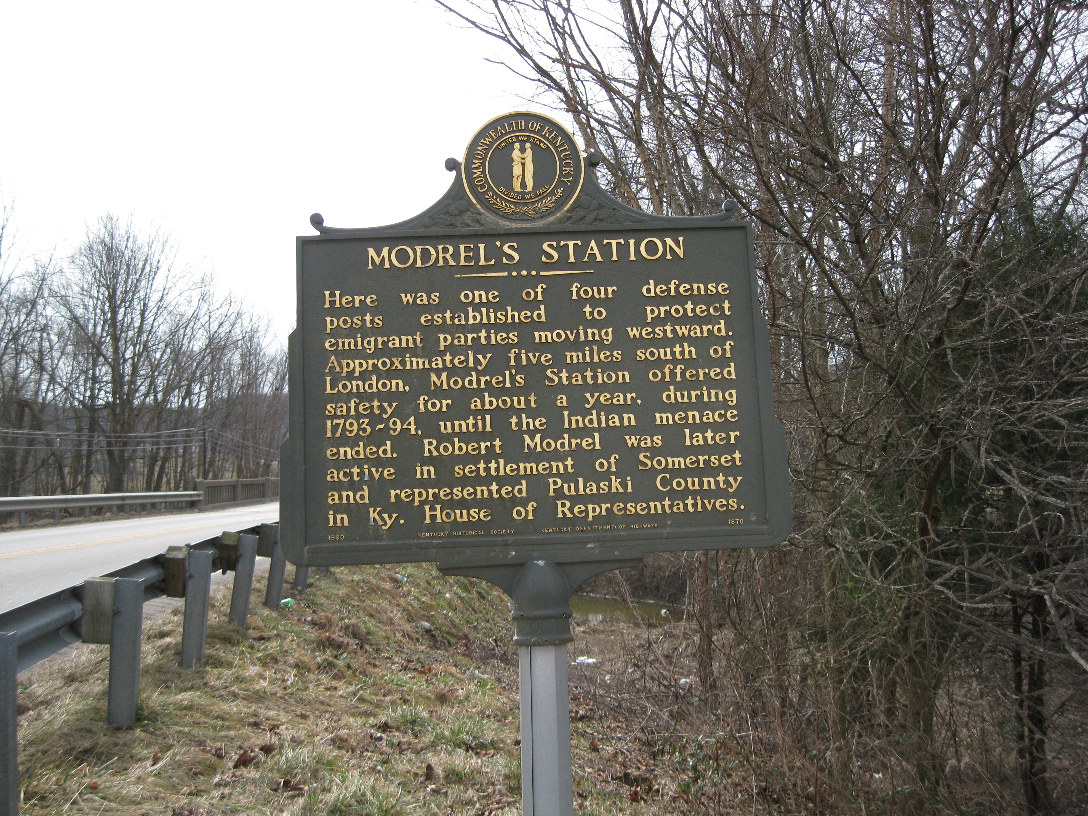 Description: Here was one of four defense posts established to protect emigrant parties moving westward. Approximately five miles south of London, Modrel’s Station offered safety for about a year, during 1793-94, until the Indian menace ended. Robert Modrel was later active in settlement of Somerset and represented Pulaski County in Ky. House of Representatives.
Pittsburg and Wilderness Road
(Marker Number: 1757)
Location: Pittsburg, Old Richmond Rd. & Crab Orchard, just off US 25
 Description: The “Madison Branch” of Wilderness Road was last 18th-century link from Cumberland Gap to central Kentucky. By legislative act of March 1, 1797, Joseph Crockett built new road from Milford, then seat of Madison Co., to intersect with improved Wilderness Road at present-day Pittsburg. This point became new “forks of the road” and replaced Old Hazel Patch crossing.
Sue Bennett College
(Marker Number: 2060)
Location: London, W. 5th [KY 1006 W] and College Streets

Sue Bennett College
Description: Sue Bennett Memorial School, named for Madison Co. promoter, opened 1897 to educate mountain children. Funded by local people and the Methodists, school taught all grades. Commercial Dept. opened 1901; county high school, 1910-33. Normal school operated, 1900-1910, and became junior college, 1922. Name changed, 1930; closed 1997. Presented by Friends of Sue Bennett.
(Reverse) Sue Bennett College – Educated more than 11,000 students, 1897-1997. School leaders: J. C. Lewis, 1897-1917; J.E. Savage, 1915-16; Ms. K.J. French, 1916-17; A.W. Mohn, 1917-22; K.C. East, 1922-42; H.V. McClure, 1939; Ms. J. Harrison, 1942-44; Ms. O. Sanders, 1944-58; L. Flynn, 1954; E.F. Hays, 1958-85; J.E. Patterson, 1985-88; Ms. J.K. Stivers, 1988-91; P.G. Bunnell, 1991-97; J. Cheek, 1997.
Swiss Colony Bernstadt
(Marker Number: 843)
Location: Bernstadt, KY 1956 & Hawk Creek Road
Description: Founded 1881, this was Kentucky’s largest foreign colony. Swiss farm crisis and high land prices caused mass emigration. Paul Schenk and Otto Bruner, agriculturalists, and Karl Imobersteg, owner of large passage office, promoted venture. These Swiss capitalists sold 4,000 acres to colonists, most from Bern. They improved farming; became known for wine and cheese production.
The Hazel Patch
(Marker Number: 53)
Location: 7 mi. N. of London, KY 490
 Description: Half mile east. Crossroads of wilderness. Skaggs Trace, 1769, Boone Trace, 1775. Here Logan disapproved Colonel Henderson’s settlement plans and parted company. Site of Wood’s Blockhouse, 1793. Earliest permanent building in wilderness.
The Wilderness Road
(Marker Number: 55)
Location: London, US 25

Wilderness Road (Courtesy Kentucky Historical Society)
Description: Opened Kentucky and the West to rapid settlement and major development. First wagon road built by Kentucky (1796), Crab Orchard to Cumberland Gap. A principal highway, maintained as a turnpike “toll road” for 80 years.
Wilderness Road Inn
(Marker Number: 927)
Location: 1/2 mi. S. of Park entrance, KY 229
Description: Site of home-tavern built, 1804, by John Freeman on Revolutionary War land grant. The tavern stood beside historic  Wilderness (wagon) Road built by Kentucky between Cumberland Gap and Crab Orchard in 1796. A principal highway, it promoted settlement of Ky. and the West. Operated as a toll road for about 80 years. Inn burned, 1962. Freeman (1761-1841) grave nearby.